In 2025, National Geographic featured Stockholm Archipelago in its Best of the World list, highlighting the newly opened Stockholm Archipelago Trail. The same year, TIME Magazine promoted the Stockholm Archipelago Trail in its World’s Greatest Places 2025 list. The unique long-distance hiking route lets you experience the variety of the archipelago all the way from north to south.
The Stockholm Archipelago Trail (SAT) launched in October 2024 and connects 270 km (168 miles) of existing paths into one continuous, waymarked route across 20 islands (divided into 21 stages/legs). All sections are reachable by public ferries, which makes it much easier for visitors to plan day hikes or multi-day trips without relying on transportation on a private boat.
Whether you’re planning your first trip to Stockholm, want to add a few days in the archipelago, or you’re a serious hiker looking for a multi-day adventure, this guide is for you.
We’ve hiked several sections ourselves, and we’ll share practical tips and firsthand experiences from the parts we’ve trekked.
Understanding the trail
The trail is divided into 22 sections, with a mix of easy, average, and challenging terrain. You don’t need to be an experienced hiker to do any of the sections, but it helps to choose sections that match your fitness and the time you have. Some legs are a relaxed half-day walk, while others are closer to a full-day hike. Several of the trails consist of several loops, making it easier to adapt the length of the hike by choosing shorter loops.
In the more technical parts, expect rocky forest paths, roots, and short but steep hills. After rain, these sections can get slippery. Easier stretches often follow wider gravel roads or well-trodden paths.
The full trail runs from the island Arholma in the north archipelago to Landsort in the south. You can reach all islands via public ferries – some directly from central Stockholm, and some from other mainland piers. This means that you can plan day trips or “island hopping” without your own boat.
During peak season (from late-June to mid-August), there are typically several daily departures on many popular routes, while off-season travel usually means fewer departures and more planning around timetables.
What’s special about the Stockholm Archipelago Trail is that it brings many separate island paths together under one clearly marked long-distance trail. You take public ferries between islands, but the route is mapped and signed as one connected experience from north to south.
Planning your adventure
When to go
The best time to go is from May to September. In summer (June–August), expected daytime temperatures are 15–25°C (59–77°F), while May and September are cooler, with temperatures 5–15°C (41–59°F). Snow and ice are very unlikely during this period, but early May (and late September) can still bring cold snaps, so it’s worth packing layers and checking the forecast before you go. Read our detailed guide on the weather in Stockholm, for more details.
The busiest month is July, when many Swedes have their summer holiday. Even during peak season the trails rarely feel crowded, but accommodation and popular restaurants can book out, especially on weekends and around peak travel dates.
In general, peak season runs from just after Midsummer (late-June) through mid-August.
Shoulder seasons are May–June and late August–September. Late summer and early autumn is the archipelago’s magical season. It runs from August to October, when the water is still relatively warm and the islands get quieter and less crowded.
Difficulty levels
Each Stockholm Archipelago Trail section is rated as Easy, Moderate, or Challenging. The ratings are based on the terrain, how technical the path is, and how many ascending and descending paths you can expect.
Easy
Non-technical walking on hard-surface or gravel roads, and in generally easy terrain. A good choice if you’re new to hiking, or if you want a relaxed walk
Moderate
More technical trails with rocks and roots, plus longer distances and more elevation than the easy sections. Best for hikers with some prior experience (and footwear with good grip).
Challenging
Narrower trails with rocks and roots, and sections of rocky terrain that can be slippery when wet. Expect frequent ascending and descending paths, including some steep parts. Best suited for experienced hikers in good physical condition, with appropriate footwear.
Island highlights
You can reach all 20 islands by public ferry – the main operator is Waxholmsbolaget. On the official sections list there are 22 entries, but two of them are connections between islands (including a short rowboat crossing and a signed connector walking path).
The islands below are some of the islands that we have enjoyed hiking ourselves. All of these are easily hikable without any prior hiking experience. There are some technical parts on the trail sections marked as Moderate difficulty, but they are still doable if you can hike for a few hours at a time. They are all in the central part of the archipelago and are a good choice for a continuous hike across islands.
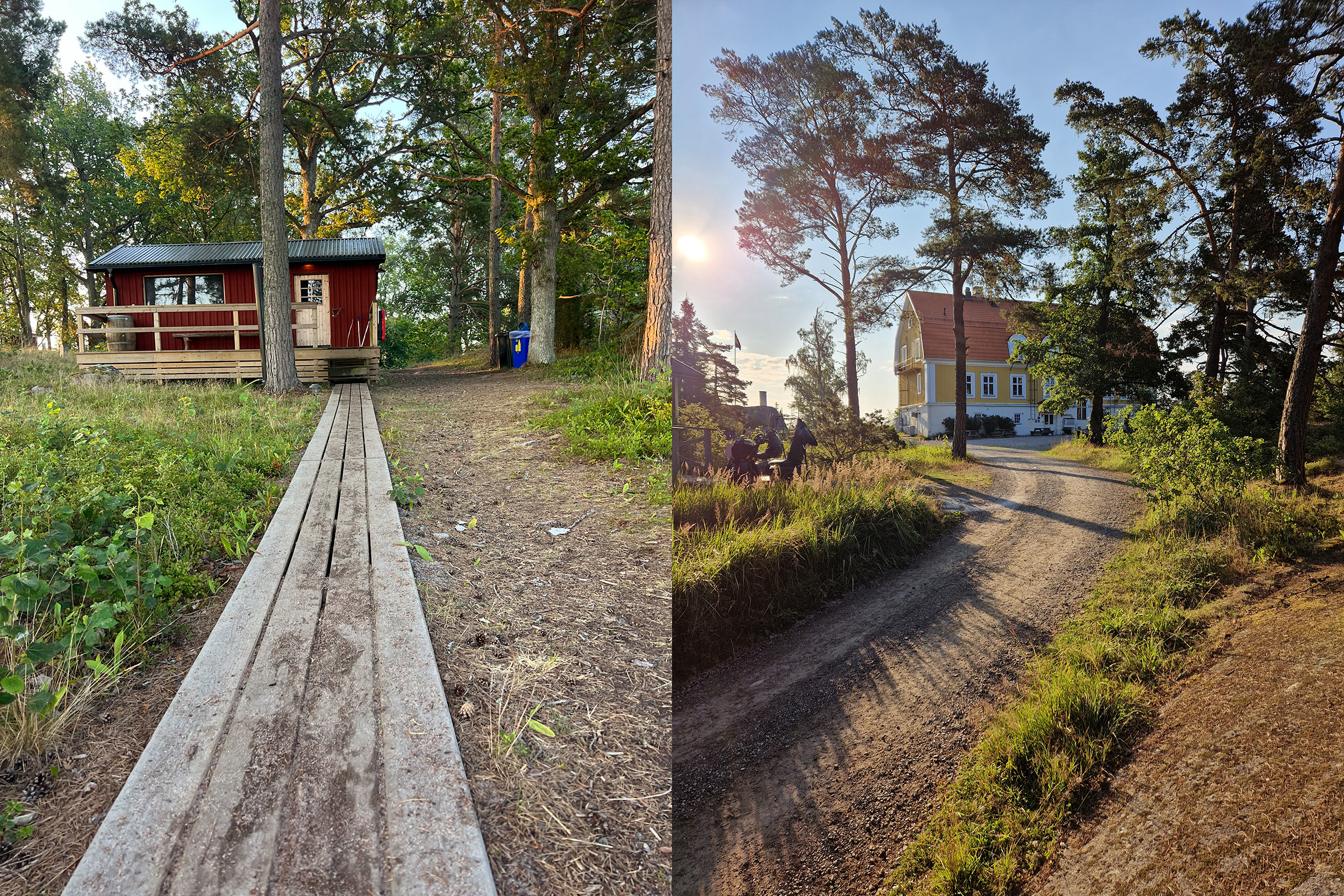
Grinda

Only 1.5 hours from Stockholm by boat, Grinda is one of the nearest archipelago islands to Stockholm. Most of the summer visitors gather around one of the two guest ports. The 9.8 km (6 miles) hiking trail is of moderate difficulty. There are some technical parts with step ascends and declines in the forest paths. You’ll alternate between gravel roads and forest paths, and the north side has more rocky, up-and-down terrain and viewpoints.
Grinda is also a practical “easy start” island because there are food options (restaurants and cafés) and places to stay near the jetties, and you can swim and rent a sauna after your hike.
Svartsö

If you want a longer but still easy walk, Svartsö is a great fit. The island pretty much has it all, with an excellent private sauna experience on the north part, to the culinary experience at Svartsö krog in the south. Stay at a hostel on the north part of the island or go for the glamping tents just by the water on the south end.
The hiking trail is easy with mostly flat gravel roads and paths that take you through meadows and forests. The full section is 17,9 km (11 miles), however the gravel roads are well suited for biking, so if you get tired of walking, get a bike to explore the full island.
Finnhamn

Finnhamn is in fact three connected islands: Idholmen, Stora Jolpan, and Lilla Jolpan. The Stockholm Archipelago Trail section here is 10.1 km (6.3 miles), rated Moderate, and laid out as three loop options that start from the same “hub” area. Each loop has their own characteristic and they are all easily hikable, with just a few technical parts in the north and south loops. We found the northern loop with its forest paths and spectacular viewpoints to be some of the best archipelago trails.
Finnhamn is very family-friendly and has plenty to do beyond hiking: you can rent kayaks or SUPs, and there’s a bookable waterside sauna.
In summer, there’s also a small film club that runs screenings (check what’s on when you arrive).
Ingmarsö

The inhabited island Ingmarsö connects gravel roads past houses, forests and busy guest ports. The 9.1 km (5.7 miles) of trail is mostly gravel roads that are easily hikable.
For a culture break, there’s a local museum at Norrgården. Food-wise, you have two strong options with different vibes: Ingmarsö Krog near the guest harbour, and Ingmarsö Bageri where you can eat in the garden (including pizza and simple meals). For accommodation, stay at the bed and breakfast near the northern quay.
If you get tired of walking, rent a bike. The roads are mostly flat gravel, so it’s an easy place to explore on two wheels.
Practical details
Getting there
Most visitors reach the Stockholm archipelago on Waxholmsbolaget’s public ferries, with many routes departing from Strömkajen in central Stockholm..
Waxholmsbolaget’s ferries run year round, however the timetables change by season. In summer there are usually more daily departures, while in the shoulder seasons and winter you’ll often need to plan more carefully around fewer departures and specific days of the week.
There’s also a private operator, Strömma, which runs ferries and cruise boats to some islands and offers sightseeing and dinner cruises. They’re usually a bit pricier than Waxholmsbolaget, but also offer lunch and dinner cruises to the archipelago and some routes are faster because they make fewer stops.
A special case is Fjäderholmarna, where you can choose between three operators: Waxholmsbolaget, Strömma, and Fjäderholmslinjen. All three arrive close to the main area. Waxholmsbolaget usually docks on the southeast jetty, about a 5-minute walk from the north jetty where most restaurants and shops are. So the choice mostly comes down to timetable, departure point in Stockholm, and price. In summer, Strömma and Fjäderholmslinjen often run very frequent direct trips. Read our detailed guide to Fjäderholmarna, for an in depth description.
Trail markings
The Stockholm Archipelago Trail is marked with ribbons and arrows in light blue and yellow, with a reflective center line in gray. Blue represents the sea, yellow represents the sun, and the reflective line is there to help in low light (for example with a headlamp).
Most sections have a recommended direction on the SAT website – clockwise or counter-clockwise. You can hike the other way, but the markings are usually easiest to follow if you stick to the suggested direction. We’ve walked several sections both ways and didn’t notice a big difference in the experience, so choose the direction that fits your plan.
Making the most of your visit
Combine with time in Stockholm
Because the archipelago is accessible by public ferry, it’s easy to combine a few days on the trail with a stay in Stockholm. Ferry travel time varies by island and route, but the ride itself is often part of the experience.
One recommended approach is to hike one or more trail sections first, then head back into the city for a night or two to explore Stockholm (or do it the other way around). If you’re looking for ideas, we have plenty of tips for anyone visiting Stockholm.
Activities beyond hiking

Combining hiking with other activities is a good way to get more out of the islands. We usually try to book at least one sauna session, which can feel great after a long day on the trail. Ending the day with a proper dinner is another easy win, and on some islands the restaurants are a destination in their own right.
For variety, try water activities like kayaking or stand-up paddleboarding (SUP). On islands with lots of gravel roads, renting a bike can also be a practical way to cover more ground, and bike rentals are available on several islands.
Sustainability tips
One of the things we love about Stockholm is how close and accessible nature is by public transport, whether that’s forests, lakes, or the archipelago.
Sweden’s Right of Public Access (Allemansrätten) means you can roam in most natural areas, including many privately owned forests and shorelines. But it’s not “go anywhere”: you should avoid private gardens, stay away from homes, and don’t walk across cultivated land or crops. The idea is simple: don’t disturb, don’t destroy.
Leave No Trace principles
A good rule of thumb is to follow the Leave No Trace approach: seven simple principles for reducing your impact outdoors. 
On the Archipelago Trail, the basics matter most:
- Stick to marked trails and durable surfaces.
- Take all litter with you (including tissues).
- Camp in suitable places and follow local rules for nature reserves and protected areas.
You can read all the principles and detailed descriptions on the Leave No Trace website.
Support local communities
Hiking in the Stockholm Archipelago is made possible by island communities that can keep year-round services running. The hiking trails that you use are also the year round trails and roads used by the locals. Many islands have small, seasonal economies and a declining population, so your choices as a visitor can make a real difference.
Concrete ways to help support the local communities:
- Stay locally (for example a family-run B&B, hostel, or guesthouse), if camping isn’t your priority.
- Eat and fika on the islands instead of bringing everything with you.
- Shop at the local grocery and supplies stores, they are often called Lanthandel.
- Look for local bakeries and farm shops selling bread, vegetables, honey, or preserves.
- Travel during shoulder season, such as May–June or September–October, as these are the periods when the local businesses are in most need of more visitors.
- Use local services like bike or kayak rentals and saunas, which helps businesses keep these services available.
Final thoughts
Hiking in the Stockholm Archipelago is more accessible than ever. With the Stockholm Archipelago Trail, you can plan trips across 20 islands using public ferries, without needing a private boat or local route knowledge.
Most sections work well for beginners, as long as you choose a distance that matches your fitness and the time you have. The more technical sections include rocky forest paths, roots, and steeper climbs, so good shoes and a bit of stamina help.
What the SAT really adds is availability, by connecting existing paths into a clearly signed route and makes it much easier to link islands together into a longer hike without spending hours on planning.
Once you’re ready to start preparing, read our detailed guide on how to book and ride the archipelago ferries and start planning your adventure.